

Tropical Storm Sandy made contact with Jamaica, as the rain and wind lashed the island it soon turned into Hurricane Sandy, this is how it began…
Hurricane Warning issued for Jamaica
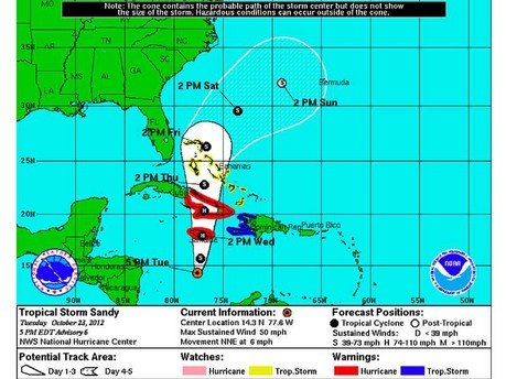
On Tuesday morning Jamaica was on Hurricane Warning as the country awaits the arrival of Tropical Storm Sandy, which is expected to hit the southern coast on Wednesday (see image above) morning. The U.S. National Hurricane Center predicts will reach hurricane category One (1) status, on the five-step Saffir-Simpson scale of hurricane intensity, with winds topping out at 80 mph (128 km).
The centre of the storm was about 260 miles (420 km) south-southwest of Kingston, the Jamaican capital, on Tuesday evening and reached top winds of 50 miles per hour (85 kph). The ‘eye’ of the storm is predicted to hit the capital before moving across the country up to the popular tourist resort of Ocho Rios dumping as much as 6 to 12 inches (15-30 cm) of rain across parts of Jamaica.
Where I am staying near to Ocho Rios the rain has fallen very heavily since this morning, except for short intermittent times where there is a lull and it falls lightly. On the other hand I have heard that apart from a small amount of rainfall this morning Montego Bay was dry for the rest of the day and into the early evening.
There hasn’t been a direct hit from the ‘eye’ of a hurricane since Hurricane Gilbert which caused considerable damage across the island in 1988 and many islanders are stocking up on food and re-enforcing roofing and other unstable areas of their homes and properties in preparation, as the acting Prime Minister Peter Phillips says that
“all Jamaicans should take the threat of this hurricane seriously”
The Prime Minister Portia Simpson Miller has cut short a 5 day visit to Canada to return to the island as authorities in Jamaica are jumping to prepare for the arrival of the hurricane.
Ministry of Education
Under recommendation from The Office of Disaster Preparedness and Emergency Management (ODPEM) the Ministry of Education has decided that schools should be closed on Wednesday and will be re-opened once it is deemed safe to do so. Many schools have been listed as disaster relief centres and have officals been advised to put away all important and expensive educational materials. The education ministry has instructed all schools to activate their emergency plans immediately.
Jamaican Airports on Lock Down
All flights from Norman Manley International Airport, Kingston have been cancelled from 10.00pm on Tuesday night when the last flight leaves Jamaica; this closure will be in effect until the storm passes. Travellers have been advised to contact their travel operator for more details, the website has updated information: http://www.nmia.aero/news_events
Sangster International airport, Montego Bay has halted all flights from 8.00am on Wednesday, until the storm has passed over the island. Travellers have been advised to contact their travel operator for more details, or check out the website for more details: http://www.mbjairport.com
Curfew Orders in Place
Minister of National Security Peter Bunting has issued curfew orders for selected areas effective from 6 p.m. Tuesday; the curfew orders would stay in effect until Thursday morning and would be enforced by members of the Police Force and Military. Only persons who work in the emergency services, those who deliver newspapers and late night workers will be allowed access in and out of the areas under curfew if they are in possession of proper identification. The curfew has been put in place in order to curtail the looting that has been known to be carried out during these types of circumstances.
The affected areas for the curfew are:
Area One
. Montego Bay
. Lucea
. Savanna-la-Mar
. Falmouth
. Duncans
. Clarkes Town
. Wakesfield
. Albert Town
. Grange Hill
. Darliston
. White House
. Hopewell
. Sandy Bay
. Green Island
Area Two
. Ocho Rios
. Port Antonio
. Port Maria
. St. Anns Bay
. Brown’s Town
. Annotto Bay
. Highgate
. Gayle
. Buff Bay
. Oracabessa
Area Three
. Mandeville
. May Pen
. Chapelton
. Lionel Town
. Frankfield
. Crofts Hill
. Christiana
. Spalding
. Porus
. Santa Cruz
. Black River
. Junction
. Balaclava
. New Market
Area Four
. Downtown Kingston
. New Kingston
. Half Way Tree
. Industrial Estate
. Winward Road
. Rockfort
. Rollington Town
. Vineyard Town
. Franklyn Town
. Mountain View
. Harbour View
. Port Royal
. Bull Bay
. Cross Roads
. Papine
. Liguanea
. Three Miles
Area Five
. Spanish Town
. Portmore
. Linstead
. Spanish Town
. Morant Bay
. Constant Spring
. Old Harbour
. Stony Hill
. Bog Walk
. Yallahs
. Seaforth
. Port Antonio
. Port Morant
. Bath
. Golden Grove
. Red Hills
. Barbican
. Golden Spring
. Lawrence Tavern
Evacuation Orders
The Office of Disaster Preparedness and Emergency Management (ODPEM) has issued mandatory evacuation orders for at-risk communities situated in low-lying areas of the country and those near to the coast or other areas that are prone to hits from hurricanes. Fisherman on the cays have been told to return to the mainland, although there are reports of about 100 fisherman that are stranded, as they do not have enough fuel for the return trip.
150 shelters have been identified across the country which people are being encouraged to move to for their own safety. Many people refuse to leave their homes as they are more concerned about looters coming in and stealing things whilst they are not at home.
Mandatory Evacuation Areas
Kingston and St Andrew
- Hope River Valley to include Kintyre, Tavern
- Bull Bay to include Taylor Lands, Weise Road, Cane River Pen and Caribbean Terrace
Clarendon
- Alley and Portland Cottage
St Catherine
- Nightingale Grove
- Sections of Lauriston closer to the Rio Cobre, Thompson Pen, Dam Head, Fairview, St John’s Road, Frazer’s Content and Hellshire Fishing Beach.
UK Foreign and Commonwealth Office Advice
The UK Foreign and Commonwealth Office web page for Jamaica, which gives updated and in-depth information about Jamaica can be found here: http://www.fco.gov.uk/en/travel-and-living-abroad/travel-advice-by-country/north-central-america/jamaica
- There is a Hurricane Warning in place for Jamaica. Tropical Storm Sandy is likely to be at Hurricane strength as it passes over Jamaica on Wednesday 24 October. Tropical Storm force winds are expected to start affecting Jamaica on the evening of Tuesday 23 October. Visitors to Jamaica, or those intending to visit, should monitor media for updates and keep in touch with tour operators or travel service providers. You can find advice on preparing for a hurricane in Jamaica here: http://ukinjamaica.fco.gov.uk/en/help-for-british-nationals/travel-advice/how-survive-hurricane
- The hurricane season in Jamaica normally runs from June to November. You should monitor weather updates.
The website for the U.S. National Hurricane Center for the latest details and diagrams of the progress of the storm can be found at: http://www.nhc.noaa.gov/refresh/graphics_at3+shtml/203623.shtml?3day#contents